- News
- City News
- trichy News
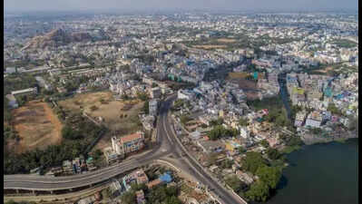
- Brace for more extreme weather in Trichy in 20 years
Trending
Brace for more extreme weather in Trichy in 20 years
Israel Iran War
- US-Israel-Iran War Live Updates: 'Indian navy's guest struck without warning': Iran slams US after torpedo sinks warship IRIS Dena
- 50 Israeli jets strike, destroy Iran Supreme Leader Ali Khamenei’s underground military bunker; IDF shares video
- Russia helping Iran? Moscow providing real time intelligence to Tehran on American military assets

About the AuthorDeepak Karthik
End of Article
Follow Us On Social Media
Hot Picks
Top Trending
Tired of too many ads?go ad free now
Trending Stories
In City
Entire Website
- Maharashtra Budget 2026 Live Updates: CM Devendra Fadnavis presents budget; ‘Ajit Pawar amar rahe’ slogans echo in assembly
- BMC plans Mumbai’s first public urban forest on 3.2-acre plot in Andheri’s Marol
- I am a tribal man, can I seek mutual divorce from my SC wife? Chhattisgarh high court says yes — here’s why
- 17-year-old dies trying to save Eid dress as Rithala fire guts 100 jhuggis in Delhi.
- A touch of Ladakh in Delhi: Rs 3-crore foot overbridge to rise near Monastery Market
- 'Cause for concern': No heatwave yet but UV radiation already a worry in Bengaluru, Kerala; what you need to know
- 25k for 3rd child: Andhra Pradesh unveils India's first draft population management policy
- Husband stitch becomes itch for women in Bengaluru: What it is and why doctors warn against it
- Nitish Kumar’s RS nomination: JDU workers vandalise office, allege BJP plot
- Nashik, Gwalior and now Assam: 3rd Sukhoi fighter jet crash in recent years; lost contact at 7.42pm — here's what happened
- US-Israel-Iran War Live Updates: Tanker hit by ‘large explosion’ off Kuwait, causing oil spill; Iran launches missiles at Israel
- UPSC CSE 2025 final results out, Anuj Agnihotri tops exam; 958 recommended for IAS, IFS, IPS and Central Services
- WBJEE 2026 notification released; examination scheduled for May 24
- Who is Anuj Agnihotri, the UPSC CSE 2025 topper?
- Russia helping Iran? Moscow providing real time intelligence to Tehran on American military assets
- 50 Israeli jets strike, destroy Iran Supreme Leader Ali Khamenei’s underground military bunker; IDF shares video
- Connor McDavid reacts after Edmonton Oilers acquire Connor Murphy, Jason Dickinson and Colton Dach before NHL trade deadline
- Qatar warns Gulf energy exports may halt within weeks if US-Iran conflict continues
- Iran’s cluster bombs: The weapon that splits in the sky and rains explosives over wide areas
- UPSC CSE 2025 toppers list: Anuj Agnihotri secures AIR 1, Rajeshwari Suve M and Akansh Dhull follow
Tired of too many ads?go ad free now


Explore Every Corner
Across The Globe
Connor HellebuyckTampa Bay LightningKam Curl ContractMontreal CanadiensJohn CarlsonsIsrael Iran WarRory McIlroyLewis HamiltonAaron RodgersSilver Rate TodayShohei OhtaniAaron JudgeNFL free agency trackerUPSC CSE Topper ListLionel MessiUPSC CSE Final ResultWBJEE 2026UP SI Exam CityTampa Bay BuccaneersCristiano RonaldoWhere Winds MeetNepal Election ResultsBrayden SchennNitish KumarSeattle KrakenAnuj AgnihotriBobby McMannWinter Paralympic Opening CeremonyUAE gold priceBrandum Mccullum
Hot on the Web
Women's Day WishesVijayShah Rukh KhanPriyanka ChopraBadshahLab Grown GoldJaved AkhtarThe Kerala Story 2Tongue Health ProblemsMagnesium DeficiencyMasterchef India WinnerRavi GhaiRajinikanth Family TreeKunal KhemuAllu Sirish & Nayanika Reddy WeddingChiranjeeviAllu ArjunGovindaYami GautamAmitabh BachchanRERA 2.0Maheika SharmaThe Great Indian Kapil Show 4Anurag DobhalDeeksha SethYoung Sherlock ReviewHoroscope TodayThe Bluff Movie ReviewBorder 2 Movie ReviewTu Yaa Main Movie ReviewToday Gold Rate in ChennaiDelhi Weather TodayDelhi AQI TodayMumbai AQI TodayMaharashtra Public Holidays 2026Maruti Brezza Facelift SpiedLab Grown DiamondsMark ZuckerbergSam AltmanSocial Media BanMaruti Suzuki e-Vitara
Trending Topics
Shohei OhtaniEileen GuSeattle KrakenBihar civil courtUP Police SI CityAnuj AgnihotriUS Jobs reportNoida airportDigital fraud rulesRussia crude export dataFrancis NgannouRahul GandhiGubernatorial ReshuffleMadhya Pradesh MurderQatar AirwaysSukhoi Su 30MKI CrashJasprit BumrahKhameneiAbu Dhabi Zayed International AirportRithala Jhuggi Fire IncidentEpstein FilesNitish KumarMamata BanerjeeJosh Berry Net WorthBrooks KoepkaJustin HerbertAlysa LiuMLB opening dayCristiano RonaldoMumbai Indians New IPL JerseyAmazon OutageMotorola Edge 70 FusionSam AltmanApple Macbook Air M5Codex Coding AppAnthropic Ceo Dario AmodeiNvidia China DreamMacbook Neo VSMacbook AirOracle LayoffsHow to watch ICC T20 World Cup 2026 in USAHow to watch ICC T20 World Cup 2026 in CanadaHow to watch T20 World Cup online in India
Popular Categories
HeadlinesSports NewsBusiness NewsIndia NewsWorld NewsBollywood NewsHealth+ TipsIndian TV ShowsTechnologyTravelEtimesHealth & FitnessHow to watch T20 World Cup OnlineIndia vs Pakistan MatchAstrologyAutoWeather TodayGold Rate Today DelhiSilver Rate TodayPlatinum Rate TodayIs Bank open todayMarch Bank HolidaysMarch Public HolidaysDeorhiTechnology NewsInternational SportsPublic HolidaysBank HolidaysT20 World Cup Squad IndiaT20 Wprld Cup Squad
Trending Videos
Princess Beatrice And Princess Eugenie Face Mounting 'Pressure' To Lose Royal StatusCanada Shock: Influencer Nancy Grewal 'Stabbed' Dead In Chilling Night Attack‘ROCKET HELL IN…’: Hezbollah Missiles Rain On Israel, IDF GATHERING Devastated In Brutal StrikeHow the 'Blue Sparrow' And Mossad Eliminated Iran’s Supreme Leader Khamenei From Space |EXPLAINEDJaipur: Dubai Return Relief, Ration Shop Row, HC On Unsafe Schools And More.Row Over Electoral Roll Revision: Protest Held at Dharmatala in KolkataNoida: Airport Security Nod, Holi Murder In Condo, Encounter Row Father Speaks And More'You Can't Trust Pakistan': Former Army Commander Breaks Down Difference Between LAC and LOCISL Highlights: Mohun Bagan Super Giants vs Odisha FCEquipment Arrived a Day Before: Army Commander Reveals Operation Meghdoot’s Race Against TimeAIIMS Jodhpur Doctor Anuj Agnihotri Tops UPSC Civil Services 2025 In Third AttemptDivya Agarwal On The 50, Divorce Rumours, Prince Narula's Game, Siwet's Anger, Rajat Dalal & VanshajRashmika Mandanna and Vijay Deverakonda share heartfelt moments from their reception in HyderabadBhubaneswar: CISF New-Age Security Focus, Go Homestay Portal, Naveen–Cong Buzz And More'Real Players Are US, Russia, China': Rahul Gandhi On Iran-Israel War, Warns Of India ImpactKochi: CPM Expulsion, Fisheries Focus, Tourism Boost & MoreMadurai: Airport Road Bridge Plan, Udhayanidhi’s Political Pitch, Caste Assault Arrests & MoreAllahabad: SHUATS Global Vision, Parking Row Shooting, Metrolite Boost & More
Latest News
'Display was religious': Ramadan decorations at Texas school taken down, conservative group says only 'secular symbols' allowed“He’s too naive”: Tom Brady’s family reportedly convinced that Alix Earle is not the one for him amid romance rumorsSt. Louis Blues Trade Captain Brayden Schenn to New York Islanders for First-Round Pick and ProspectIn marathon outreach, NCW plans week-long public hearings covering 500 districts'Yaadein' actor Iqbal Khan enjoys a fun banter with Akshay Kumar on 'Wheel of Fortune'NHL Trade Rumor: Toronto Maple Leafs trade Bobby McMann to Colorado Avalanche as teams reshuffle their rosterRs 30 crore for empowerment of disabledUK to offer up to £40,000 to failed asylum-seekers to leave countryState to spend Rs 45cr on new police HQQuota, jobs and confirmation, all in state govt deptsEvery MLA to get approval for public works worth Rs 100 croreTribal sportspersons get shot in the arm with new schemeA lesson in education: NEP infra funds missingWhy limiting social media before 16 may be good for your child: Experts explain the parenting benefitsUK: Brawl breaks out at Holi event in Harrow, one heldAhead of 2027 polls, govt supports ST community with incentives and dolesBudget speech sign-off takes turn for the verseRs 500 crore push for Kushavati development
Copyright © 2026 Bennett, Coleman & Co. Ltd. All rights reserved. For reprint rights: Times Syndication Service