- News
- City News
- chennai News
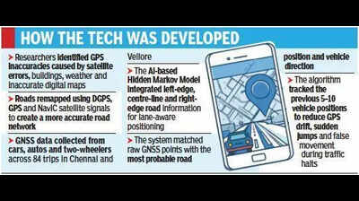
- New AI-based navigation to enhance GPS accuracy
Trending
New AI-based navigation to enhance GPS accuracy
End of Article
Follow Us On Social Media

Hot Picks
Top Trending
Tired of too many ads?go ad free now
Trending Stories
In Chennai
In City
- Ponraj booked for making derogatory remarks on TVK women cadres
- International probe, referendum, only path to justice for Eelam Tamils: Ramadoss
- ED writes to Tamil Nadu govt seeking sanction to prosecute Senthil Balaji
- Coaching centres make hay as NEET courses commence
- Farmer attempts self-immolation at Krishnagiri collectorate
- Tamil Nadu CM Vijay orders renovation of Amma canteens
- Tamil Nadu govt transfers senior bureaucrats including Gagandeep Singh Bedi; Greater Chennai Corporation gets new commissioner
- Two-language policy is fundamental to TVK, says Tamil Nadu minister Rajmohan
- ‘I feel exhilarated, not jealous’: Rajinikanth on Vijay becoming Tamil Nadu CM
- Thangam Thennarasu rebuts Keerthana’s charge on Tamil Nadu’s debt
- Residents force rethink: MahaMetro likely to shift station and realign route in Thane
- Temporary Bailey bridge coming up on damaged Vikramshila Setu
- Concretisation planned: Bengaluru’s ORR commuters set for 1 year of traffic chaos
- ‘Shooter’ in Bengal CM’s aide murder case arrested near Muzaffarnagar toll plaza
- Dubare fallout: Ban on feeding, bathing elephants across Karnataka
- ED writes to Tamil Nadu govt seeking sanction to prosecute Senthil Balaji
- Blue Line Metro in Bengaluru could be powered fully by solar: Indian Institute of Science study
- Ground staff’s 3-hr flash strike leaves AI passengers stranded at Mumbai airport
- Blood donations hit by heat across govt, pvt hospitals in Mumbai
- Mumbai crime branch closes case of extortion against fugitive gangster Guru Satam
Tired of too many ads?go ad free now


Explore Every Corner
Across The Globe
IPL Points TableCSK vs SRHVaibhav SooryavanshiVirat KohliPreity ZintaIPL Playoff ScenariosMK StalinDonald TrumpDak Prescott ExRajasthan High Court Driver Result 2026Roger and Mirka Federer Net WorthAndre Agassi and Steffi Graf Net WorthFifa World Cup ControversyCSK vs SRH IPL Match TodayR AshwinDeepak SinglaTom BradyLauren KyleNHL Trade RumorsEvander KaneCaitlin RanceUS Iran WarIPL Purple Cap WinnerFloyd Mayweather JrSidney CrosbyAravindh ChithambaramFIFA World Cup 2026Ronda RouseyMegan Thee StallionIPL Match Today

Hot on the Web
Ashok SarafAmit ShahRaaj KumarHarsh ChhayaRashmika MandannaDubare Elephant Camp TragedyYashYuvraj SinghAanjjan SrivastavIrrfan KhanVirat KohliJanhvi KapoorSalman KhanK Rajan Death NewsParag TyagiDipika KakarGlass Shower Screens Cleaning TipsUnique Fruit TreesKaruppu Box Office CollectionKhan SirChandranaag IdentityPopular FoodAC Room Water Bucket TipsMeta LayoffsPanchayat Season 5Anti Lizard TipsHbA1cHypertension SymptomsRaja Shivaji Box Office CollectionHoroscope TodayCuba Drone ThreatFatah 3 VS BrahmosUS Powerball LotteryRajnath SinghUAE Nuclear PlantSanjeev AroraNyt ConnectionsUmar Khalid CaseLegal Document PropertyClaim Fixed Deposit After DeathGhost Of The WoodsCaptions For Instagram Posts
Trending Topics
CSK VS SRH IPL MatchKarnataka Wildlife Camp TragedyMSCE Pune Scholarship Result 2026Mushfiqur RahimMacneil Hadley NoronhaLondon Tube Strikes SuspendedMushfiqur RahimNTA Recruitment 2026Dani CarvajalSanju SamsonShan MasoodBangladesh measles deathMamata BanerjeeUAE nuclear plant attackCSK VS SRH Match PreviewUS fighter jet collisionIPL ScheduleTrump China VisitBCCI RTI ActNavya GadusuMS DhoniPBKS Qualification ScenarioStrait of HormuzEA FC 26 La Liga TOTS players leakedUP StormMicah Parsonsmike vrabel dianna russini controversyKerala CM AnnouncementSiddaramaiahFortnite V40 Release timeJensen HuangMarc BenioffApple GenmojiSaaS DeadHack Of The DayElon Musk Instagram RemarkIndian-American Tech MillionaireHonda City FaceliftGarena Free Fire MAX Redeem CodesPeroxide CodesGenshin Impact Codes
Popular Categories
HeadlinesSports NewsBusiness NewsIndia NewsWorld NewsInternational SportsHealthIndian TV ShowsTechnologyTravelEtimesAstrologyDeorhiAutoTechnology NewsGold Rate TodayWeather TodaySilver Price TodayDelhi Weather TodayPetrol Price TodayDiesel Price TodayCNG Price TodayLPG Price TodayPetrol Price MumbaiDelhi AQIIs Bank Open TodayMumbai AQI TodayIs Bank Open TomorrowPublic Holidays in MayBank Holidays in May
Trending Videos
Cate Blanchett’s Powerful Message On Freedom And Fear Goes Viral At Cannes Iran Wins OIL WAR? Trump 'BACKS OFF', Agrees To Lift U.S. SANCTIONS On Tehran's Black Gold - ReportMoscow Backs Iran’s Right to Enrich Uranium Amid "Neo-Colonial" US Sanctions‘Brace For Ruthless Response’: China's Draws Redline Just Days After Trump Visit | DETAILS'Time Has Come': Suvendu's 'Deportation' Warning In Bhabanipur, Vows Action Over Kolkata ViolenceSingapore PM Wong's Alarming Warning On Iran-Hormuz | ‘More Escalation, Destruction & Uncertainty’Kash Patel Under Fire After VIP Pearl Harbor Snorkeling Trip Sparks Ethics Fury | WATCHDelhi High Court Denies Interim Relief To Vinesh Phogat, Wrestler Barred From Asian Games TrialsBhopal 'Dowry Death' Shocker: Twisha Sharma's Last Message SurfacesVishal questions Vijay's ministry move, says Tamil film industry is bleeding; Jana Nayagan buzz“India Is Now Naxal-Free”: Home Minister Amit Shah Declares End Of Maoist Insurgency From Bastar'I Am Trapped': Twisha Sharma's Last Message Before 'Dowry Death' In Bhopal | Headlines@9Soni Razdan and Ameesha Patel back Alia Bhatt after Cannes trolling controversyRam Charan’s ‘Peddi’ Trailer Sparks Madness; Ram Charan Compared To Virat KohliPak Deploys 8000 Troops, Fighter Jet Squadron, Drones & Chinese Air Defence System To SaudiHarry Styles Responds To Pro-Palestine Chant At Amsterdam Concert, Viral Clip Sparks DebateNo Margin For Error: How Fighter Pilots Eject In EmergenciesIranian Military Bombards Kurdish Targets In Northern Iraq; Foil Potential Destablisation Plan
Latest News
Hazaribag man drowns while fishing in lake"Behen Darr Gayi!": Fans relive ‘Bhagam Bhag’ era after watching Akshay Kumar's 'Bhooth Bangla' trailerMBOSE HSLC result 2026 to release tomorrow: Check details hereIran war risk: JPMorgan CEO Jamie Dimon warns of oil shocks, sticky inflation and higher interest ratesMake your clutch last longer with these easy driving tips“Three-against-one situation”: El Rubius opens up on being “targeted” in MrBeast’s viral $1M challengeBihar BTSC lab assistant notification released for 1091 posts at btsc.bihar.gov.in; apply hereIPL craze costs techie Rs 1.46 lakh in fake RCB vs CSK ticket scamRaising “robot-proof” kids: Why creativity and curiosity matter more than everInside ‘Satguru Sharan’: Exploring Saif Ali Khan and Kareena Kapoor Khan’s Rs 100 crore Bandra homeHow selling Alaska in 1867 was a costly mistake for Russia'Hera Pheri 3 is coming': Paresh Rawal dismisses delay reports and reveals he will 'start shooting soon'US-Iran War: A daring rescue Hollywood blockbuster is on its way. Till then, pick your favourite from these 10 films on bringing someone home against all oddsKolkata team unveils fan mural at Rash Behari Avenue, celebrating city’s first loveHow US spread a lie to rescue a pilot of a jet shot down in IranNetflix unveils ‘VOID’, an AI model that can change a movie plotAI data centers are causing 'stress' not just to tech companies, but also private insurers"Trans women are.....": Clavicular’s viral moment with trans women sparks fresh conversation on internet culture
Copyright © 2026 Bennett, Coleman & Co. Ltd. All rights reserved. For reprint rights: Times Syndication Service