
- News
- City News
- kolkata News
- Cyclone Dana to form on Wednesday, head for Bengal-Odisha coast
Trending
Cyclone Dana to form on Wednesday, head for Bengal-Odisha coast
A cyclone named 'Dana' is forecast to form over the east-central Bay of Bengal, impacting the Bengal-Odisha coast with heavy rain and gusty winds from Oct 23 to 24. The storm may intensify to a 'severe cyclonic storm' with wind speeds up to 120kmph and is expected to affect coastal and southern Bengal.

The city is likely to receive moderate rain on Wednesday, which could intensify into heavier showers on Thursday.
The coastal districts — Howrah, East and West Midnapore and North and South 24 Parganas — are also likely to be lashed by heavy rain between Wednesday and Friday.
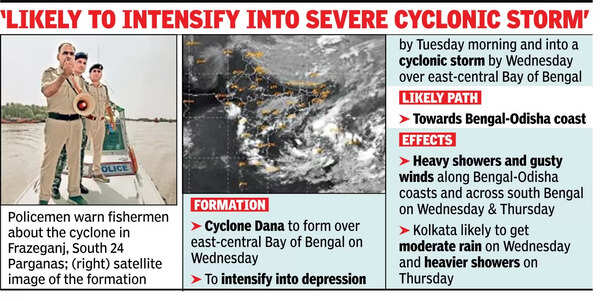
A bulletin issued by the Regional Meteorological Centre (RMC) on Sunday said Saturday's cyclonic circulation over central Andaman Sea lay over North Andaman Sea in the early morning of Sunday and persisted over the region till the afternoon.
"Under its influence, a low-pressure area is very likely to form over east-central Bay of Bengal and adjoining north Andaman Sea during the next 24 hours. It is very likely to move west-northwestwards and intensify into a depression by Oct 22 morning and into a cyclonic storm by Oct 23 over east-central Bay of Bengal," the bulletin said.
It added that the cyclonic storm is likely to move north-westwards to reach northwest Bay of Bengal, off the Odisha-Bengal coast, by Oct 24 morning. The storm is likely to intensify into a "severe cyclonic storm", said India Meteorological Department (IMD) DG Mrutyunjay Mohapatra.
IMD, however, has ruled out the possibility of the impending cyclonic storm intensifying into a super cyclonic storm or extremely super cyclonic storm. "However, according to the prediction made on Sunday, the cyclonic storm may intensify into a severe cyclonic storm. The wind speed may reach up to 100kmph to 120kmph," an IMD statement said.
"Its path, wind speed and intensity will be predicted after the system intensifies into depression from low pressure," said RMC weather scientist H R Biswas. "But it's now clear that it will head north-northwestwards towards the Bengal-Odisha coast. We expect maximum impact on south Bengal between Oct 23 and 26," he added.
The last cyclone to hit the Bengal coast was Remal, on May 26. It had made landfall between Sagar Island in Bengal and Khepupara in Bangladesh as a severe cyclonic storm. Remal had a windspeed of 100kmph to 130kmph, causing 84 deaths.
The IMD issued a warning for the Odisha-Bengal coastal area, saying, "Squally wind speed reaching 40kmph to 50kmph gusting to 60kmph is very likely to commence from Oct 23 evening. It would gradually increase, becoming gale wind speed, reaching 100kmph to 110kmph gusting to 120kmph from Oct 24 night till Oct 25 morning."
Fishermen have been advised not to venture into the Andaman Sea till Monday (Oct 21), Central Bay of Bengal till Oct 23 and north Bay of Bengal till Oct 25 along the Odisha, Bengal and Andhra coasts. If they are already at sea, they must return to the coast by Monday, the IMD has advised.
End of Article
FOLLOW US ON SOCIAL MEDIA










Photostories

Hot Picks
TOP TRENDING
Popular Categories
Hot on the Web
Top Trends
IPL 2025 RetentionMumbai Indians Retention ListKing CharlesUP Police Constable ResultUS Election 2024 LiveIPL 2025 Full Retention ListKamala HarrisCSK Retention ListDiwali 2024 LiveKKR Retention ListDelhi Capital Retention ListRCB Retention ListDelhi AQI TodayZac TaylorIPL Remaining PurseIsrael Iran WarDiwali 2024World Test Championship
Trending Topics
Diwali WishesSalman KhanDiwali 2024 WishesTop Diwali WishesAmaran Social ReviewDiwali 2024 Puja TimingKaun Banega Crorepati 16Diwali Pooja TimingDevara OTT ReleaseVicky Vidya Ka Woh Wala Video CollectionAbhishek BachchanAnanya PandayRishad Yusuf Death NewsSmriti MandhanaOptical illusionDiwali Bank HolidaysMaroon 5Wordle Answer
Living and entertainment
Latest News
Dreame Technology Hair Glory hair dryer review: Get stylish and healthy hairHoroscope Today, November 1, 2024: Read your today's astrological predictionsWho is Karthik Naralasetty? Indian-American tech innovator who could be Texas’s youngest mayorAmericans brace for gridlock amid talk of voter fraud and stolen electionRajesh Khanna's special Diwali connection with Supriya Pathak's father'Breaking party to obtain power was inappropriate': Sharad Pawar slams Ajit Pawar's factionGT Retention List 2025: Full list of Gujarat Titans Players retentions before IPL 2025 mega auction'It's black day for us': Mehbooba Mufti on J&K's UT foundation dayTrump rides garbage truck to troll Harris and Biden: The best memes and jokesTabu takes over New York in a crushed silk Angrakha by Abu Jani Sandeep KhoslaIndia's growth can't be dependent on a few groups: Kotak'One nation, one election impossible': Mallikarjun Kharge reacts to PM Modi's remarksAll hail Red Espresso! The South African beverage rises as a global super-drinkAmitabh Bachchan allegedly ignores Aishwarya Rai and skips mentioning Aaradhya on his quiz show amid divorce rumours with Abhishek BachchanWhen Sara Ali Khan said her job as an actor was done before her film releasesLaxmi Puja 2024: Date, City Wise Puja Muhurat, Puja Vidhi, Laxmi Mantra and Laxmi Mata AartiLSG Retention List 2025: Full list of Lucknow Super Giants retentions before IPL 2025 mega auctionShabana Azmi shares photos from her Diwali bash; says 'Happy Diwali Sabko'
Copyright © 2024 Bennett, Coleman & Co. Ltd. All rights reserved. For reprint rights: Times Syndication Service